Digital modelling and data management for the conservation of masonry structures
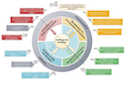
In the field of built heritage, a variety of data are used to describe the state of a monument (survey and scientific imaging data, maps of deterioration, photographic collections, historical archives, analysis documents, core sampling, etc.). Faced with the difficulty of collecting, comparing, analysing and validating data prior to restoration, this project aims to mobilise various disciplinary fields (architecture, conservation, mechanics, IT) in order to define a prototype information processing chain (including metric and spatial data, surface analyses, geometric models of structures, heterogeneous documentary sources, etc.). The aim is to design and develop an open, extensible software platform for capitalising on and managing knowledge to help understand and analyse the deterioration phenomena affecting historic buildings.
As part of a highly multi-disciplinary approach, this project aims to take rational charge of all the technical elements (based on the interconnection of technological building blocks already developed by the consortium partners), by integrating them into a methodological reflection linked to the scientific questions raised by the real objects of study. In terms of computer modelling, this project has two innovative features: on the one hand, the idea of linking (and bringing closer together) the spatial data acquisition phase with that of its analysis and interpretation; on the other, the ambition to develop analysis media (building morphology, surface condition, structural behaviour) interconnected by a semantic characterisation system based on distribution/propagation (multi-scale and multi-projection) mechanisms for concepts structured within a domain ontology.
Website: http://www.monumentum.map.cnrs.fr/
Partners: UMR MAP, ENSG-IGN, UMR LMGC, FRE CRMD, DRAC-Paca
Contact: Livio De Luca
Founding: 2013-2017. ANR Contenus et Interactions